|
|
|
By Michael Perry
SYDNEY (Reuters) - A 16th century maritime map in a Los Angeles library vault proves that Portuguese adventurers, not British or Dutch, were the first Europeans to discover Australia, says a new book which details the secret discovery of Australia.
The book "Beyond Capricorn" says the map, which accurately marks geographical sites along Australia's east coast in Portuguese, proves that Portuguese seafarer Christopher de Mendonca lead a fleet of four ships into Botany Bay in 1522 -- almost 250 years before Britain's Captain James Cook.
Australian author Peter Trickett said that when he enlarged the small map he could recognize all the headlands and bays in Botany Bay in Sydney -- the site where Cook claimed Australia for Britain in 1770.
"It was even so accurate that I found I could draw in the modern airport runways, to scale in the right place, without any problem at all," Trickett told Reuters on Wednesday.
Trickett said he stumbled across a copy of the map while browsing through a Canberra book shop eight years ago.
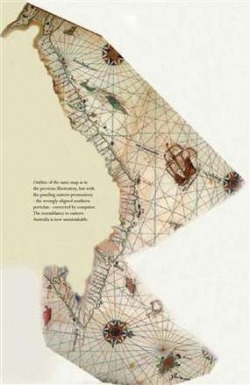
He said the shop had a reproduction of the Vallard Atlas, a collection of 15 hand drawn maps completed no later than 1545 in France. The maps represented the known world at the time.
Two of the maps called "Terra Java" had a striking similarity to Australia's east coast except at one point the coastline jutted out at right angles for 1,500 km (932 miles).
"There was something familiar about them but they were not quite right -- that was the puzzle. How did they come to have all these Portuguese place names?," Trickett said.
Trickett believed the cartographers who drew the Vallard maps had wrongly aligned two Portuguese charts they were copying from.
It is commonly accepted that the French cartographers used maps and "portolan" charts acquired illegally from Portugal and Portuguese vessels that had been captured, Trickett said.
"The original portolan maps would have been drawn on animal hide parchments, usually sheep or goat skin, of limited size," he explained. "For a coastline the length of eastern Australia, some 3,500 kms, they would have been 3 to 4 charts."
"The Vallard cartographer has put these individual charts together like a jigsaw puzzle. Without clear compass markings its possible to join the southern chart in two different ways. My theory is it had been wrongly joined."
Using a computer Trickett rotated the southern part of the Vallard map 90 degrees to produce a map which accurately depicts Australia's east coast.
"They provided stunning proof that Portuguese ships made these daring voyages of discovery in the early 1520s, just a few years after they had sailed north of Australia to reach the Spice Islands -- the Moluccas. This was a century before the Dutch and 250 years before Captain Cook," he said.
Trickett believes the original charts were made by Mendonca who set sail from the Portuguese base at Malacca with four ships on a secret mission to discover Marco Polo's "Island of Gold" south of Java.
If Trickett is right, Mendonca's map shows he sailed past Fraser Island off Australia's northeast coast, into Botany Bay in Sydney, and south to Kangaroo Island off southern Australia, before returning to Malacca via New Zealand's north island.
Mendonca's discovery was kept secret to prevent other European powers reaching the new land, said Trickett, who believes his theory is supported by discoveries of 16th century Portuguese artifacts on the Australian and New Zealand coasts. Mar, 2007

click na foto para ver em tamanho grande
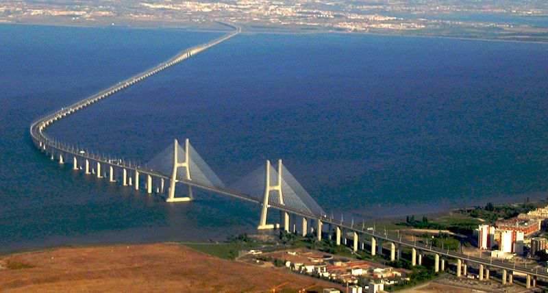
Ponte Vasco da Gama. Portugal que tem 10km sobre agua

Austrália foi descoberta pelos Portugueses ?
Ângela Marques
Seja feita justiça: foram os portugueses e não os britânicos, nem os holandeses, que descobriram a Austrália. Foram os portugueses e isso só não se soube antes por culpa
dos franceses. É o que afirma um livro publicado na Austrália, que mostra uma carta náutica abandonada numa biblioteca de Los Angeles, nos Estados Unidos, provando que
Cristóvão de Mendonça foi o primeiro a pôr os pés no território. Só que uma tradução mal feita em França escondeu durante séculos o seu feito.
O jornalista e historiador australiano Peter Trickett encontrou os dois mapas da polémica "por acaso". E não tem dúvidas: "Eles fornecem provas notáveis de que navios
portugueses fizeram essas viagens corajosas de descoberta em 1520. Isso foi um século antes dos holandeses e 250 anos antes do capitão James Cook [que reclamou para o
Reino Unido a descoberta em 1770]", diz.
Em entrevista à Reuters, Trickett disse que se deparou com uma cópia do mapa numa livraria há oito anos. Ali encontrou uma reprodução do Atlas Vallard, uma colecção de
15 mapas feitos à mão até 1545 em França. Dois deles intitulavam-se "Terra Java" e apresentavam semelhanças com a costa australiana. "Havia algo familiar neles, mas
também havia algo de errado, era um quebra-cabeças. Porque teriam aqueles lugares nomes portugueses?", inquietou-se. Cerca de 120 locais tinham nomes em português.
Trickett percebeu então que os cartógrafos franceses poderiam ter alinhado mal dois mapas portugueses. "Os mapas originais teriam sido desenhados em pergaminhos de pele
de carneiro ou cabra, de tamanho limitado. Para uma costa do tamanho do leste da Austrália, de 3500 quilómetros, seriam precisos três a quatro mapas", explicou o historiador.
A explicação para o engano será então que "sem marcações de bússolas claras era possível juntar o mapa de duas maneiras". E os franceses tê-lo-ão feito da pior maneira,
da maneira errada. Para Trickett, os mapas foram feitos por Cristóvão de Mendonça, que saiu de Portugal com quatro navios numa missão secreta para descobrir a "Ilha do
Ouro" de Marco Pólo, no sul de Java. Tendo descoberto a Austrália, terá mantido o feito em segredo para evitar que outras potências europeias da época se lhe seguissem.
Title: Beyond Capricorn
Author: Trickett, Peter
Publisher: East Street Publications
ISBN: 097511459X
Year Published: 2007
Binding: Paperback
In Beyond Capricorn, Peter Trickett challenges the commonly held view that the European discovery of Australia and New Zealand was made first by the Dutch, followed later
by Britain's Captain James Cook. Trickett argues the remarkable claim that in the year 1522 - a century before the Dutch and 250 years before Captain Cook - the Portuguese
sailed past Fraser Island and into Botany Bay, around Wilson's Promontory, and as far as Kangaroo Island before returning to their base in Malacca via the North Island of New
Zealand.
Drawing from primary and secondary historical sources, archaeological evidence and stories handed down through Aboriginal oral tradition, Peter Trickett tells a story of
espionage, revenge and secret voyages made by the Portuguese to corner the fabulously rich spice trade in the east and find the islands of gold alluded to by Marco Polo.
Secret voyages that resulted in the discovery of Australia and New Zealand almost 500 years ago.
Beyond Capricorn is a compelling account of how for a brief moment in the 1520s Australia and New Zealand came close to becoming Portuguese outposts in the southern seas.

CURIOSIDADES: AUSTRALIA
Localização: Oceania entre o Oceano Índico e o Oceano Pacífico - 27 00 S, 133 00 E
Área: 7.686.850 km quadrados incluindo ilhas. ( Sexto maior do mundo)
Países Fronteiriços: Nenhum
Extenção da Costa Marítima: 25.760 km
Extenção da Grande Barreira de Corais: 2.200 Km
Mar territorial: 12 Milhas Nauticas
Zona econômica exclusiva: 200 Milhas Nauticas
Clima: Árido à Semi-Árido, Temperado no Leste e Sul, Tropical no Norte.
Terreno: Plano baixo com Montanhas no Leste e no Sudeste.
Ponto mais baixo: Lake Eyre - 15 metros abaixo do nível do mar
Ponto Culminante: Mount Kosciuszko 2.229 metros acima do nível do mar.
Recursos Naturais: Carvão, Bauxita, Ferro, Cobre, Ouro, Prata, Uranio, Nickel, Tungstenio, Chumbo, Zinco, Diamante, Petróleo, e Gás Natural.
Desastres Naturais: Ciclones ao longo da Costa Norte, Nordeste e Noroeste, Sêca em todo o continente, Incêndios Florestais
População Total: 19,546,792 (2002)
0 a 14 anos 20.4% ( Homens: 2.046.052 Mulheres: 1.949.725)
15 a 64 anos 67.0% ( Homens: 6.610.840 Mulheres: 6.480.354)
Acima de 65 anos 12.6% ( Homens: 1.078.506 Mulheres: 1.381.315)
Crescimento Populacional: 0.96% por ano.
Mortalidade Infantil: 4.9 em 1000 nascimentos.
Expectativa de Vida: Média: 80 anos ( Homens: 77 anos - Mulheres: 83 anos)
Taxa de Fertilidade: 1.77 nascimentos por Mulher
Grupos Étnicos: Caucasianos 92%, Asiáticos 7%, Aborígienes e outros 1%
Religião: Anglicanos: 26.1%, Cotólico Romano: 26%, Cristãos: 24.3%, Outras: 22.6%
Taxa de Alfabetização: 100% acima de 15 anos de idade.
Sistema de Governo: Parlamentarista, Democrático, com Sistema Federativo.
Capital Federal: Canberra
Divisão Territorial: 6 Estados: New South Wales- Queensland - Victoria - South Australia - West Australia - Tasmania. 2 Territórios: Northen Territory e Australian Capital Territory (ACT)
Outros Territórios dependentes: Ilhas Ashmore, Cartier, Christmas, Cocos, Ilhas no Coral Sea, Ilhas Heard, McDonald, e Norfolk.
Independência: 1 de Janeiro de 1901
Dia da Austrália: 26 de Janeiro.(feriado nacional)
Maioridade: 18 anos, Universal e Compulsória
Partidos políticos: Australian Democrats, Australian Labor Party, Country Labor Party, Australian Greens, Liberal Party, National Party, One Nation Party.
Taxa de Inflação: 2.8 % ao ano
Taxa de Desemprego: 5.6 % da população economicamente ativa.
Moeda: Australian Dollar (AUD)
Importações: $ 68 Bilhões Exportações: $ 66.3 Bilhões (2002)
Dívida Externa: $ 176.8 Bilhões (2001)
Renda per Capita: $ 27.000 Dollares/ habitante

History of Portugal
The early history of Portugal is shared with the rest of the Iberian peninsula. The region was visited by Phoenicians and Carthaginians, settled by Celts, incorporated in the Roman empire (as Lusitania in 138 BC), settled again by Suevi, Buri and Visigoths and conquered by Muslims. In 868, during the Reconquista, the First County of Portugal was formed. A victory over the Muslims at Ourique in 1139 is traditionally taken as the occasion when Portugal is transformed from a county into an independent kingdom.
On June 24, 1128, Afonso Henriques, Count of Portugal, defeated his mother, Countess Teresa, and her lover, Fernão Peres de Trava, in battle - thereby establishing himself as sole leader. Afonso Henriques proclaimed himself king of Portugal on July 25, 1139, after the Battle of Ourique and was recognized as such in 1143 by Alfonso VII, king of León and Castile, and in 1179 by Pope Alexander III.
Afonso Vaz and his successors, aided by military monastic orders, pushed southward to drive out the Moors, as the size of Portugal covered about half of its present area. In 1249, this Reconquista ended with the capture of the Algarve on the southern coast, giving Portugal its present day borders, with minor exceptions.
In 1373, Portugal made an alliance with England, which is the longest-standing alliance in the world.
In 1383, the king of Castile, husband of the daughter of the Portuguese king who had died without a male heir, claimed his throne. An ensuing popular revolt led to the 1383-1385 Crisis. A faction of petty noblemen and commoners, led by John of Aviz (later John I), seconded by General Nuno Álvares Pereira defeated the Castilians in the Battle of Aljubarrota. This celebrated battle is still a symbol of glory and the struggle for independence from neighboring Spain.
In the following decades, Portugal spearheaded the exploration of the world and undertook the Age of Discovery. Prince Henry the Navigator, son of King João I, became the main sponsor and patron of this endeavor.
In 1415, Portugal gained the first of its overseas colonies when a fleet conquered Ceuta, a prosperous Islamic trade center in North Africa. There followed the first discoveries in the Atlantic: Madeira and the Azores, which led to the first colonization movements.
An anachronous map of the Portuguese Empire (1415-1999). Red - true possessions; Pink - explorations, areas of influence and trade and claims of sovereignty; Blue - main sea explorations, routes and areas of inluence.
Throughout the 15th century, Portuguese explorers sailed the coast of Africa, establishing trading posts as they looked for a route to India and its spices, which were coveted in Europe. In 1498, Vasco da Gama finally reached India and brought economic prosperity to Portugal and its then population of one million residents.
In 1500, Pedro Álvares Cabral, en route to India, discovered Brazil and claimed it for Portugal.Ten years later, Afonso de Albuquerque conquered Goa, in India, Ormuz in the Persian Strait, and Malacca in what is now a state in Malaysia. Thus, the Portuguese empire held dominion over commerce in the Indian Ocean and South Atlantic. It may also have been Portuguese sailors that were the first Europeans to discover Australia] .[3
Portugal's independence was interrupted between 1580 and 1640. Because the heirless King Sebastian died in battle in Morocco, Philip II of Spain claimed his throne and so became Philip I of Portugal. Although Portugal did not lose its formal independence, it was governed by the same monarch who governed Spain, briefly forming a union of kingdoms; in 1640, John IV spearheaded an uprising backed by disgruntled nobles and was proclaimed king. This was the beginning of the dynasty of Braganza, which was to reign until 1910.
By this time, however, the Portuguese empire was already under attack from other countries, specifically Britain and the Netherlands. Portugal began a slow but inexorable decline until the 20th century. This decline was hastened by the independence in 1822 of the country's largest colonial possession, Brazil.
In 1910, a revolution deposed the Portuguese monarchy, but chaos continued and considerable economic problems were aggravated by the military intervention in the First World War, which led to a military coup d'état in 1926. This in turn led to the establishment of a right-wing dictatorship by António de Oliveira Salazar.
In the early 1960s, independence movements in the colonies of Angola, Mozambique, and Portuguese Guinea resulted in the Portuguese Colonial War. In 1974, a bloodless left-wing military coup known as the Carnation Revolution led the way for a modern democracy as well as the independence of the last colonies in Africa shortly after. Portugal joined the European Union in 1986, and ever since it has engaged in a process of convergence with its EU counterparts.

As maiores pontes do mundo.
Nota: Não há uma maneira padronizada de medir o comprimento total de uma ponte. Algumas pontes são medidas desde o início da rampa de
"entrada até ao fim da saída. Algumas são medidas de margem a margem, outras ainda correspondem ao comprimento total construído."
Daí que a ordenação abaixo tenha que ser vista apenas como uma orientação.
Pontes Nome Extensao(metros) Vao(metros) Ano conclusão País
"[1]Causeway do lagoon Pontchartrain 38,445 ? 1969 Estados Unidos"
"[2] Donghai (maior ponte sober o mar 24.6 km) 31,500 420 2005 China"
"[3]Causeway do Rei Fahd 25,000 ? 1986 Arábia Saudita/Bahrain"
"[4]Ponte Vasco da Gama 17,185 420 1998 Portugal"
"[5]Ponte Penang 13,500 225 1985 Malásia"
"[6]Ponte Rio-Niterói 13,332 300 1974 Brazil"
"[7]Ponte Confederation 12,900 250 1997 Canadá"
"[8]Ponte San Mateo-Hayward 11,265 22 1967 Estados Unidos"
"[9] Ponte Seven Mile 10,887 41 1982 Estados Unidos"
"[10]Terceira Ponte Mainland 10,500 ? 1991 Nigeria"
"[11]Ponte Shandong-Henan Yellow River 10,282 ? 1985 China"
"[12] Ponte Twin Span 8,851 ? 1963 Estados Unidos"
"[13] Ponte do logo Maracaibo 8,678 235 1962 Venezuela"
"[14] Ponte do Øresund 7,845 490 1999 Dinamarca/Suécia"
"[15] Ponte James River 7,425 126 1983 Estados Unidos"
"[16]Ponte Gwangan 7,420 500 2002 Coreia do Sul"
"[17] Ponte Huey P. Long 7,009 241 1936 Estados Unidos"
"[18] Ponte Chesapeake Bay 6,946 488 1952(este)1973(oeste) Estados Unidos"
"[19] Ponte Great Belt (Oriental) 6,790 1,624 1998 Dinamarca"
"[20] Ponte Nanjing Yangtze River 6,772 160 1968 China"
"[21] Ponte Sunshine Skyway 6,663 366 1987 Estados Unidos"
"[22] Ponte Great Belt (Ocidental) 6,611 110 1994 Dinamarca"
"[23] Ponte Astoria-Megler 6,545 375 1966 Estados Unidos"
"[24] Ponte Öland 6,072 130 1972 Suécia"
"[25 Hernando de Soto Bridge 5,954 274 1 972 Estados Unidos"
"[26] Ponte Mahatma Gandhi 5,850 ? 1982 India"
"[27] Ponte Hell Gate 5,182 298 1916 Estados Unidos"
"[28] Second Severn Crossing 5,126 456 1996 Reino Unido"
"[29] Ponte Zeeland 5,022 95 1965 Países Baixos"
"[30] Ponte Tappan Zee 4,881 369 1955 Estados Unidos"
"[31] Ponte Bangabandhu 4,800 100 1998 Bangladesh"
"[32] Ponte Sault Ste. Marie International 4,506 ? 1962 Estados UUUnidos/Canadá"
"[33] Ponte Tokyo Bay Aqua-Line 4,384 ? 1997 Japão"
"[34] Ponte Champlain 4,182 215 1962 Canadá"
"[35] Ponte New Vicksburg 3,954 257 1973 Estados Unidos"
"[36]Ponte Köhlbrand 3,940 520 1974 Alemanha"
"[37]] Ponte Akashi-Kaikyo 3,911 1,991(o maior vão) 1998 Japão"
"[38] Ponte Lupu 3,900 550 2003 China"
"[39] Ponte flutuante Evergreen Point 3,781 ? 1963 Estados Unidos"
"[40] Ponte Skygate R 3,750 ? 1991 Japão"
"[41] Ponte San Diego-Coronad 3,407 201 1969 Estados Unidos"
"[42]Terceira Ponte 3,300 260 1989 Brazil"
"[43] Ponte Storstrøm 3,199 138 1937 Dinamarca"
"[44] Ponte Brahmaputra 3,015 120 1987 India"
"[45] Ponte Jiangyin Suspension 3,000 1,385 1999 China"
"[46] Ponte Rio-Antirio 2,880 560 2004 Grécia"
"[47] Ponte Saratov 2,804 ? 1965 Rússia"
"[48] Ponte Victoria 2,790 ? 1898 Canadá"
"[49] Ponte Godavari Rail 2,745 27 1997 India"
"[50] Ponte Golden Gate 2,737 1,280 1937 Estados Unidos"
"[51] Laviolette Bridge 2,704 335 1967 Canadá"
"[52] Ponte Jacques Cartier 2,687 334 1930 Canadá"
"[53] Ponte Houghton Highway 2,685 ? 1979 Austrália"
"[54] Ponte Mackinac 2,626 1,158 1957 Estados Unidos"
"[55] Ponte Khabarovsk 2,590 127 1916 reconstr.1999 Rússia"
"[56 Ponte West Gate 2,583 336 1978 Austrália"
"[57] Burlington Bay Skyway 2,560 325 1958 Canadá"
"[58] Ponte Richard I. Bong Memorial 2,559 ? 1985 Estados Unidos"
"[59] Forth Rail Bridge 2,529 521 1890 Escócia"
"[60] Forth Road Bridge 2,512 1,006 1964 Escócia"
"[61] Ponte Zilwaukee 2,466 119 1988 Estados Unidos"
"[62] Viaduct Millar 2,460 342 2004 France"
"[63] Ponte John A. Beatnik 2,430 ? 1961 Estados Unidos"
"[64] Ponte Kingston-Rhine cliff 2,375 244 1957 Estados Unidos"
"[65] Ponte Ambassador 2,283 564 1929 Canadá / Estados Unidos"
"[66] Ponte 25 de Abril 2,278 1,013 1966 Portugal"
"[67] Ponte Humber 2,220 1,410 1981 Reino Unido"
"[68] Ponte San Janice 2,200 1,377 1979 Filipinas"
"[69] Ponte Abraham Lincoln Memorial 2,170 189 1987 Estados Unidos"
"[70] Ponte Sting Ma 2,160 1,377 1997 Hong Kong"
"[71] Ponte da Normandy 2,143 856 1995 France"
"[72] Ponte Port Man 2,093 366 1964 Canadá"
"[73] Ponte Manhattan 2,089 448 1912 Estados Unidos"
"[74] Ponte Surged 2,070 408 2000 Rússia"
"[75] Ponte Verazinc-Narrow 2,034 1,298 1964 Estados Unidos"
"[76] Ponte Raped 2,000 103 1950 Hungria"
"[77] Eads Bridg 1,964 158 1874 Estados Unidos"
"[78] Ponte Malaysia-Singapore Second Link 1,920 165 1998 Malásia/Singapore"
"[79] Ponte Draymen 1,892 60 1975 Noruega"
"[80] Ponte Brooklyn 1,834 486 1883 Estados Unidos"
"[81] Ponte Hogan Kustner 1,800 1,210 1997 Suécia"
"[82] Ponte Faro (sulk) 1,726 290 1985 Dinamarca"
"[83] Ponte Minami Bisan-Seto 1,678 1,100 1988 Japão"
"[84] Ponte Sallingsund 1,717 93 1978 Dinamarca"
"[85] Ponte Vejle Fjord 1,712 110 1980 Dinamarca"
"[86] Ponte New Little Belt 1,700 600 1970 Dinamarca"
"[87] Ponte Angostura 1,678 712 1967 Venezuela"
"[88] Ponte Ting Kau 1,675 475 2004 China"
"[89] Ponte das Americas 1,654 344 1962 Panama"
"[90] Ohnaruto Bridge 1,629 876 1985 Japão"
"[91] Viaduct Lethbridge 1,624 35 1909 Canadá"
"[92] Ponte Kita-Bisan 1,611 990 1985 Japão"
"[93] Ponte Faro (norte) 1,596 40 1985 Dinamarca"
"[94] Ponte Cedar Avenue 1,580 ? 1979 Estados Unidos"
"[95 Terceira ponte Kurushima-Kaikyo 1,570 1,030 1999 Japão"
"[96] Gerald Desmond Bridge 1,565 321 1968 Estados Unidos"
"[97] Segunda Ponte Kurushima-Kaiky 1,515 1,020 1999 Japão"
"[98] Ponte do Bósforo 1,510 1,074 1973 Turquia"
"[99] Ponte Fatih Sultão Mehmet 1,510 1,090 1988 Turquia"
"[100] Tatara Bridge (Shimanami Kaido) 1,480 890 1999 Japão"
"[101] Ponte George Washington 1,451 1,06 1931 Estados Unidos"
"[102]Ponte Shimotsui-Seto 1,447 940 1988 Japão"
"[103] Ponte Krk 1,431 390 1980 Croácia"
"[104] Ponte Mjøsa 1,421 69 1985 Noruega"
"[105] Ponte Tasman 1,417 43 1964 Austrália"
"[106] Canso Causeway 1,385 94 1955 Canadá"
"[107] Ponte Rio Irtysh 1,374 231 2004 Rússia"
"[108] Ponte Honoré Mercier 1,361 122 1934 Canadá"
"[109] Ponte Innoshima 1,339 770 1983 Japão"
"[110] Van Brienenoordbrug 1,320 288 1965 Países Baixos"
"[111] Ponte Gjemnessund 1,257 623 1992 Noruega"
"[112] Ponte Mendota 1,255 93 1926 Estados Unidos"
"[113] Ponte Sandnessund 1,248 150 1973 Noruega"
"[114 Ponte Nordhordland 1,246 113 1994 Noruega"
"[115] Ponte Sotra 1,236 468 1971 Noruega"
"[116] Ponte Måløy 1,224 125 1974 Noruega"
"[117] Ponte Finnsnes 1,220 143 1972 Noruega"
"[118] Ponte Svendborgsund 1,220 90 1966 Dinamarca"
"[119] Ponte Little Belt (antiga) 1,178 220 1935 Dinamarca"
"[120] Ponte Akinada 1,175 750 1999 Japão"
"[121] Ponte Sydney Harbour 1,149 503 1932 Austrália"
"[122] Ponte Kiso Gawa 1,145 275 2001 Japão"
"[123] Viaduct Negrelli 1,110 25 1849 República Tcheca"
"[124] Ponte Yanjisha 1,084 360 2000 China"
"[125] Ponte Stord 1,077 677 2000 Noruega"
"[126] Ponte Kanmon 1,068 712 1973 Japão"
"[127] Ponte Stavanger 1,067 185 1978 Noruega"
"[128] Ponte Helgeland 1,065 425 1991 Noruega"
"[129] Ponte Askøy 1,057 850 1992 Noruega"
"[130] Viaduct Crni Kal 1,056 141 2004 Eslovênia"
"[131] Ponte Replot 1,045 250 1996 Finlândia"
"[132]Ponte Pierre Laporte 1,041 667 1970 Canadá"
"[133] Ponte Hadsel 1,020 150 1978 Noruega"
"[134] Ponte Tromsø 1,016 80 1960 Noruega"
"[135] Ponte Skarnsund 1,010 530 1991 Noruega"
Did You Know...
Considered to be the rarest gem in the world, ammolite is the product of the fossilization of the ammonite, a prehistoric creature that abounded, some 65 million years ago during the Cretaceous period, in the seas that once covered the region of Alberta in western Canada. The stone is extremely popular among Orientals, especially among followers of Feng Sui, a Chinese philosophy based on Bhuddist concepts that studies the flux and irradiation of energies. With chromatic properties that include the seven colours of the prism, ammolite is considered by Feng Suists to be the Stone of Prosperity, bestowing upon its user spiritual, mental and material well-being. Throughout the centuries native prospectors have sought out the stone for its magical properties. Today, ammolite is mined industrially in Alberta in the only mine of its kind in the world.
The duckbilled platypus is an amphibian oviparous (lays eggs) mammal native to Australia and Tasmania. It has fur and webbed feet as well as a beak similar to that of a duck.
The altitude of Mount Everest, the highest mountain in the world, increases several millimetres a year due to the effect of geological forces.
The first climber to reach its summit (about 8, 850m above sea level) was New Zealander, Sir Edmund Hillary in 1953.
The first woman to perform this feat was Junko Tabei from Japan on May 16, 1975.
The first Portuguese was João Garcia on May 18, 1999, but the adventure resulted in the loss of his fingertips and nose reconstruction.
In 1850 the population of the city of Toronto, Canada, was
30 000 and a happy lot they were because back then one could purchase alcoholic beverages in any one of the city's 152 taverns and 206 beer shops.
The first divorce to have taken place in Canada was in the town of Halifax in 1750.
Pierre Elliot Trudeau was the only Canadian Prime Minister to have married whilst in office.
A 7lb codfish (3.8 kg) can produce 7 million eggs at one time.
Canada's largest island is Baffin Island in the Arctic Ocean.
Elizabeth Barrett Browning was one of the greatest English poets of the Victorian Era. Caught between the rigid moral standards of her time and the flight of a free spirit Elizabeth Barrett finally meets Robert Browning, a young talented Scottish poet with whom she falls in love after having lead a cloistered and isolated life due to her fragile health and the demands of a severe father. They marry in secret and run off and settle in Italy.
The anthology Sonnets from the Portuguese is compiled of love sonnets she wrote to her beloved Burns. He had nicknamed her the Portuguese because of her dark olive skinned complexion. Nonetheless, the title does intimate possible Portuguese literary influences on her work.
Sonnets from the Portuguese
Sonnet IX
Can it be right to give what I can give?
To let thee sit beneath the fall of tears
As salt as mine, and hear the sighing years
Resighing on my lips renunciative
Through those infrequent smiles which fail to live
For all thy adjurations? O my fears,
That this can scarce be right! We are not peers,
So to be lovers; and I own, and grieve,
That givers of such gifts as mine are, must
Be counted with the ungenerous. Out, alas!
I will not soil thy purple with my dust,
Nor breathe my poison on thy Venice-glass,
Nor give thee any love, which were unjust.
Belovèd, I only love thee! let it pass.
Catherine of Braganza, besides being responsible for the habit of tea drinking among the British people, also introduced the use of the fork to the English court.
The oldest standing academic premium in the United States was instituted by the 18th century Portuguese physicist, John Hyacinth Magellan. It is the Magellanic Premium Award of the American Philosophical Society in Philadelphia. The renowned American scientist and statesman, Benjamin Franklin, founded the society. The award is given to the best discovery or invention in navigation, astronomy or natural philosophy. John Hyacinth Magellan - a descendent of the Portuguese explorer Ferdinand Magellan -was born in the town of Aveiro, Portugal, home of the John Hyacinth Magellan Foundation (Fundação João Jacinto Magalhães). A respected scientist in the scientific milieu of his time, he dedicated much of his work to the development of scientific instruments. He lived for the better part of his life in London where he died in 1790. He was a member and correspondent of the Academia das Ciências, Lisbon; Académie Royal des Sciences, Brussels; Académie des Sciences, Paris; Imperial Academy of Science, Saint Petersburg; Akademie der Wissenschaften, Berlin; American Philosophical Society, Philadelphia; Hollandsche Maatschappij der Wetenschappen, Haarlem; Real Academia de las Ciencias, Madrid; the Literary and Phylosophical Society, Manchester and the Royal Society of London.
The secular ties between the English and the Portuguese have greatly influenced the eating habits of both peoples. To think food and Portuguese is to think "bacalhau" (codfish). But most likely the Portuguese owe their taste for cod to the English, who commenced cod fishing in the colder waters of the British Isles as back as the 14th century. The fish was salted and dried to preserve it on the return journey. Britain's climate did not favour viticulture and thus the British had to look to neighbouring countries on the European mainland for wines. Thus, surplus production of salted cod was used in exchange for wine. In Portugal this trade was initially centred in and around Ribadavia, The Ave River Valley, region that produces vinho verde. The Reformation started in the middle of the 16th century further diminished the demand for fish on the English market, largely due to the conversion of a vast segment of the English population to Protestantism. As these no longer followed the Catholic precepts regarding the consumption of meat, English traders were forced to augment their codfish outlets abroad, further enhancing the consumption of cod on the Portuguese markets.
Port wine was not always greatly appreciated by the English. For centuries Portuguese wines were seen as poor substitutes for French Wines as can be seen in this ditty dating back to the Jacobite Revolution in the 17th century. King William's Loyalists expressed their disdain for the Highlander supporters of Charles Stuart or Bonny Prince Charlie and pretender to the throne, in ditties such this:
Firm and erect the Highland chieftain stood,
Sweet was his mutton and his claret good,
"Thou shalt drink Port," the English statesman cried;
He drank the poison, and his spirit died.
Firme e altivo apresentou-se o chefe de clã das Terras Altas,
Dulce a sua carne de carneiro e bom o seu clareto
"Beberás Vinho do Porto," o estadista inglês vociferou:
Ele bebeu o veneno e o seu espírito esmoreceu.
(Free Portuguese translation by- Adiaspora.com)
King Alfonse IV of Portugal and not King Ferdinand ordered the edification of the Fernandine Walls in Porto as their designation might imply. The latter simply completed the 40-year Afonsine project started in 1336.
The historical veracity of the existence of Vimara Peres (9th century), supposed Delegate of the King of the Asturias in the province that later was to become the earldom of Portucale is shrouded in doubt. The Town of Guimarães, Cradle of the Portuguese Nation, owes its name to this historical personage. Some historians believe that he was a mere invention of the new State regime (Salazar) to incite patriotic fervour in the people of Porto by inaugurating a statue of the Lord of Vimara on a presidential visit to the Unconquered City by Américo Tomás.
Note: Porto is often called the Invicta or Unconquered for no invading force has ever been able to take the city.
To date there has been only one Portuguese Pope, Pedro Julião better known as Pedro Hispano (Peter, the Spaniard). He ascended the Throne of Peter in 1276, having died one year later when the ceiling of his quarters collapsed. Pedro Hispano was a man of letters and science and among many other important positions he held during his lifetime was that of Professor of Medicine at the University of Siena.
The first patron saint of Portugal and protector of King Afonso Henriques. When in battle against the Saracens in Santarém, it seems the first Portuguese monarch requested aid from on High. It was granted in the form of a cloud from which descended the winged fist of Saint Michael, the Archangel, branding a sword with which the enemy was warded off. The King gave thanks by founding the Order of São Miguel da Ala (St. Michael of the Wing) and consecrating the country to the Warrior Angel.
Prince Henry, The Navigator, and the driving force behind the Portuguese Maritime saga was born in the locality of Ribeira, Porto on March 4, 1434. Tradition has it that the birth took place in what is today the Casa do Infante.
The long, celebrated and fruitful Anglo-Portuguese alliance began with the signing of the Treaty of Windsor in 1386 and the subsequent marriage of King João I of Portugal with the Phillipa of Lancaster in the City of Porto the following year.
According to the annals of history a party of immigrants from the Island of Madeira, Portugal, under contract to work on the sugar plantations, landed in Hawaii in 1879. One of them, overjoyed at the prospect of a new and better life to come, started dancing on the quay and singing songs of the old homeland to the tune of the braquinha. The Hawaiians were so impressed by the musicality, timbre and simple execution of the instrument that they soon incorporated the braquinha into their own popular music. Its syncopated rhythm and sound reminded them of a jumping flea or, that is, a ukelele.
The persecution that targeted the Iberian Jews forced them into exile or conversion to Christianity. Many took on the external trappings of Christianity but secretly practiced the Jewish rites in the privacy of their homes, far from the eyes of Inquisition informers. That renowned Portuguese delicacy, the Alheira, was created as a means of self-preservation. The slaughtering of the pig and pork sausages was the custom among the Christians. So the marranos, forbidden by the precepts of the Judaism, came up with a sausage made of a mixture of bread, venison and chicken which, when hung before the fireplace, as did the Christians, would fool any more inquisitive or over zealous neighbour. The alheira has come to be part of the gastronomic culture of the County of Mirandela, (Province of Trás-os-Montes, Portugal) and bears witness to the presence of the Sephardic Jews in the region.
Note: Marrano is a Portuguese term for converted Jews who practiced Judaism in secret.
Winston Churchill had great affection for the Island of Madeira where he would often spend time painting its landscapes. It was the illustrious British statesman who first described Madeira as "The Pearl of the Atlantic".
The Madeira Archipelago was discovered by João Gonçalves Zarco, Tristan Vaz Teixeira and Barthlomew Perestrello purely by chance in 1418 when they were driven off course by a bad storm while sailing to the West African Coast.
The origin of the toponym, Island of Madeira, resided in the existence of great forests and subsequently wood on the island when it was first discovered. The Portuguese word "Madeira" means "wood".
Christopher Columbus lived on the Islands of Porto Santo and Madeira for some time and where he married the daughter of Port Captain Bartlomew Perestrello.
Immediately after the death of his father King João I of Portugal, and with the consent of his brother Duarte, successor to the throne, Prince Henry, The Navigator, consecrated the Madeira Archipelago to the Order of Christ, to which he belonged.
The Island Of Bombay was handed over to England by Portugal as a result of the marriage in 1662 of Charles II of England, the first constitutional monarch, to the Portuguese Infanta, Catherine of Braganza, daughter of King John IV of Portugal. The island was part of her dowry.
Catherine of Braganza introduced tea drinking in England. It became so popular with her English subjects that tea is now very much part of British culture and world image.
When the British took over the former Dutch Colony, New Amsterdam was renamed New York after the Duke of York and brother of Charles II of England. The popular N.Y. borough of Queens was so called in honour of Catherine of Braganza, wife to Charles II and its first queen.
Vasco de Gama's brother, Paulo, came to die in the Azorean Town of Angra do Heroismo on the return leg of their first and historical trip to India.
The Azorean Town of Angra do Heroismo was the headquarters of Portuguese government (1580-1583) during the Spanish occupation of Portugal.
Brianda Pereira wreaked havoc during the attempted invasion of the Island of Terceira, The Azores, by the Spanish in 1581. During the Battle of Salga she intrepid and ingeniously steered her cattle towards the invading troops, stopping them in their tracks. Cervantes, author of Don Quixote de la Mancha, took part in this battle.
As from 1693 couriers secured postal service between Quebec and Montreal. It seems that the first courier was Peter da Silva from Portugal.
Nossa Senhora da Conceição (Our Lady of the Conception) is the patroness of Portugal. She was so proclaimed in 1646 by King João IV.
Saint George, the Christian martyr, is the patron of Portugal, Brazil and England.
The Japanese lexicon did not contain a word to express thanks until the arrival of the Portuguese on the archipelago in the 16th century. The Portuguese word for thanks, "obrigado", now appears in the Japanese language as "arigato".
The Chinese invented the toothbrush and the compass.
The illustrious British physicist and mathematician, Sir Isaac Newton, was a premature baby and so small that he was said to fit "in a beer mug".
Zacuto, a marrano and astronomer to King Manuel I of Portugal, invented the maritime astrolabe in 1501.
Behaim Martin, German mapmaker and navigator, built the first globe, "The Nurnburg Terrestrial Globe". He was also advisor to King João I of Portugal on matters of navigation and accompanied Diogo Cão on his exploratory journey to the West African coast (1485-1486) when the mouth of the River Congo was first uncovered by Europeans.
The Q-tip was invented in the1920's by Leo Gerstenzang, a Polish-born American.
Labrador owes its name to the Portuguese explorer, João Fernandes, a farmer on his native Island of Terceira, The Azores. He is said to have reached the coast of what is now Greenland in 1500, having given the name of Lavrador (or farmer in Portuguese) to these lands. In the course of time, however, the toponym came to designate the lands further south, namely modern day Labrador.
There was at least one probable attempt to establish a Portuguese colony in Newfoundland. João Alvares Fagundes of Viana do Castelo, Portugal, who explored the south coast of Newfoundland in 1520, headed the expedition. It is said that finding the land too cold the colonists moved further west to less inhospitable lands. Some historians speculate as to whether they may have settled in the Cape Breton area or Mira Bay (Bahia de Mira). Apparently, the colony failed due to the hostility of local natives.
Sabia que...
Sabia que...
No principio do século XIX aumenta o interesse pelo desporto nas universidades inglesas e começa a jogar-se um futebol menos violento.
Em Outubro de 1863 são criadas em Cambridge as regras do futebol moderno.
Em 1864 é decidida em Inglaterra a colocação de pequenas bandeiras nos cantos do rectângulo de jogo, para avisar o público que não devia passar para dentro dessas linhas.
Em 1871, é estipulada em Inglaterra a existência de um "guardador da baliza" - goal keeper -, o único que pode tocar a bola com as mãos enquanto nessa área.
Em 1873 foi criado o pontapé de canto.
Em 1881 foi estipulada em Inglaterra pela primeira vez a presença de um árbitro em todos os desafios de futebol.
Em 1882 foi criada a regra da reposição da bola em jogo com as mãos, quando ela saía pelas linhas laterais.
Em 1890 foi introduzido o pontapé de grande penalidade nas leis do futebol.
Em 1891 o árbitro passa a ser assistido por fiscais de linha.
Em 22 de Janeiro de 1897, registou-se a primeira vitória de um clube português frente a um grupo estrangeiro - o Casa Pia bateu os ingleses do Carcavellos, por 2-0.
O futebol aparece pela primeira vez como desporto olímpico em 1900, nas Olimpíadas de Paris.
O Sport Lisboa é fundado por 24 sócios, em 28 de Fevereiro de 1904.
Em Março de 1904, o Major José da Cruz Viegas, depois de consultar alguns catálogos de fábricas inglesas, escolhe o vermelho e o branco para cores do Sport Lisboa.
A Federation Internationale de Football Association (FIFA) foi fundada em 21 de Maio de 1904.
Em Junho de 1905, o Sport Lisboa somava só por vitórias os encontros da primeira metade do ano.
Em 1906, a imprensa considera o Grupo Sport Lisboa o melhor clube de jogadores portugueses da capital.
Em 26 de Julho de 1906, é fundado o Grupo de Sport Benfica (que se viria a ligar com o Sport Lisboa em 1908, dando lugar ao Sport Lisboa e Benfica), com 15 sócios e apenas as modalidades de velocipedismo (ciclismo) e pedestrianismo (atletismo).
O Grupo Sport Lisboa constitui o seu primeiro grupo infantil em Julho de 1906.
Em 1907, Cosme Damião é simultaneamente sócio do Grupo Sport Lisboa e do Grupo Sport Benfica.
A Liga Portuguesa de Futebol institui pela primeira vez uma Taça para o Campeonato de 1ª Categoria no ano de 1908. Em 1910, a edição do troféu passa a ser tutelada pela Associação de Futebol de Lisboa.
Em 1908, foi instituída definitivamente a Liga Portuguesa de Futebol, com regulamentos, estatutos e taças.
O nome Sport Lisboa e Benfica é instituído em 13 de Setembro de 1908, após a junção do Grupo Sport Lisboa com o Sport Clube de Benfica.
Em Setembro de1908, realiza-se o primeiro campeonato, a que o Sport Lisboa e Benfica concorre.
Em 1909, Cosme Damião é nomeado capitão-geral da equipa e director do Sport Lisboa e Benfica.
João José Pires, primeiro presidente do Sport Lisboa e Benfica, é eleito em 26 de Fevereiro de 1909.
A Liga Portuguesa de Futebol inscreve-se na FIFA a 16 de Novembro de 1909.
Em Outubro de 1909, espalham-se pelo País os primeiros núcleos do Sport Lisboa e Benfica.
Em 1910, o Sport Lisboa e Benfica ganha a Taça da Liga Portuguesa de Futebol e a Taça dos Jogos Olímpicos Nacionais.
Em Novembro de 1910, a Associação de Futebol de Lisboa organiza o primeiro Campeonato de Lisboa.
Em 28 de Abril de 1912, o Sport Lisboa e Benfica desloca-se ao Porto a convite do FC Porto.
Em 28 de Abril de 1912 a ida ao Porto do Sport Lisboa e Benfica dá um prejuízo de 13$27.
Em Junho de 1912, o Benfica tem a sua primeira saída ao estrangeiro - Corunha.
Em 1913, o Sport Lisboa e Benfica constrói o novo campo de Sete Rios em tempo record, conseguindo utilizá-lo ainda nessa época.
Em 16 de Fevereiro de 1913, é fundado o Desportos de Benfica, a primeira sucursal ou filial do Sport Lisboa e Benfica.
Em Junho de 1913, o Sport Lisboa e Benfica ganha a Taça de Futebol nos Jogos Olímpicos Nacionais, por falta de comparência do Sporting Clube de Portugal.
A 8 de Junho de 1913, o Sport Lisboa e Benfica conquista a Taça Camões.
Em 24 de Agosto de 1913, é lançado o semanário "O Sport Lisboa", o primeiro jornal de clube existente em Lisboa.
A 4 de Novembro de 1913, o Sport Lisboa e Benfica tem 523 sócios.
Em 1914, António Ribeiro dos Reis, com apenas 17 anos, começou a colaborar no jornal O Sport Lisboa.
Em 1914, a sede do Sport Lisboa e Benfica centra a sua actividade em torno do jornal e da campanha que determinará a fundação da Federação Portuguesa de Sports.
A 28 de Fevereiro de 1914, o Sport Lisboa e Benfica tem 607 sócios.
A 16 de Setembro de 1914, o Sport Lisboa e Benfica castiga Artur José Pereira com 6 meses, por indisciplina. O Sporting Clube de Portugal recebe-o.
Em Novembro de 1914, é criada a delegação do Sport Lisboa e Benfica em Braga: Estrela Futebol Clube de Braga.
O Sport Lisboa e Benfica atinge os 1000 associados em Junho de 1915.
Na época de 1915/16, o Sport Lisboa e Benfica é campeão nas 4 categorias.
A 1 de Janeiro de 1916, o Sport Lisboa e Benfica organiza o Torneio das 4 cidades, em Sete Rios, e convida o FC Porto, o Racing de Madrid e o Montriond Sport de Lausanne.
A 8 de Janeiro de 1917, é constituído o Grupo Dramático do Sport Lisboa e Benfica.
A 3 de Junho de 1917, a imprensa refere-se pela primeira vez a um jogo de Hóquei em Patins - duas equipas do Sport Lisboa e Benfica jogam no rinque da Av. Gomes Pereira.
A 25 de Julho de 1917, o Sport Lisboa e Benfica propõe a realização do I Campeonato Nacional de Patinagem, instituindo a própria Taça.
A 10 de Novembro de 1918, sai o 1.º número do jornal "O Vermelho", pequeno semanário editado por um grupo de benfiquistas.
Em 1919, é introduzida a modalidade de luta no Sport Lisboa e Benfica.
A 23 de Setembro de 1919, é fundado o Belenenses, como resultado de dissidências no Sport Lisboa e Benfica.
A 20 de Dezembro de 1919, realizaram-se as provas de selecção do Comité Olímpico Português para os Jogos Olímpicos de Antuérpia.
Em 1921, é introduzida a modalidade de tiro no Sport Lisboa e Benfica.
22 de Julho de 1921, o Sport Lisboa e Benfica organiza um torneio de Atletismo, no qual participam 193 atletas, representando 16 clubes.
A 1 de Dezembro de 1921, a Associação de Futebol de Lisboa informa os jornais da exclusão de alguns jogadores da Selecção Nacional, por motivos vários.
Na época de 1921/22 é instituída a Selecção Nacional.
Em 1922, o Maritímo convida o Sport Lisboa e Benfica a deslocar-se à Madeira.
A 5 de Abril de 1922, a comitiva do Sport Lisboa e Benfica inicia a primeira viagem de um clube continental à Madeira.
Em Outubro de 1922, o Sport Lisboa e Benfica retribuindo um convite do Marítimo, convida o clube insular a deslocar-se ao continente.
Em 1923, é introduzido o Hóquei em Campo no Sport Lisboa e Benfica.
A 4 de Fevereiro de 1923, o Sport Lisboa e Benfica nomeia o Marítimo do Funchal seu Sócio Honorário n.º 1, devido a troca de visitas.
Em 28 de Agosto de 1923, devido à crise no Sporting Clube de Portugal, o Sport Lisboa e Benfica põe as suas instalações à disposição do clube rival.
Em 1924, é introduzido o Râguebi no Sport Lisboa e Benfica.
A 4 de Agosto de 1924, o Sport Lisboa e Benfica vence o Concurso de Desportos Atléticos e conquista a Taça do Século, sendo o clube com maior número de pontos.
Em Maio de 1925, a União Portuguesa de Futebol nomeia António Ribeiro dos Reis para o cargo de seleccionador nacional.
A 30 de Junho de 1925, o Sport Lisboa e Benfica tem 3026 sócios.
A 10 de Setembro de 1925, o Sport Lisboa e Benfica vence o 1.º Campeonato de Portugal de Patinagem.
A época de 1925/26 fica assinalada por inovações. São modificadas as leis das deslocações: redução do número de jogadores necessários para colocar um jogador em off-side de 3 para 2.
A 28 de Março de 1926, o nome da União Portuguesa de Futebol muda para Federação Portuguesa de Futebol.
1 de Agosto de 1926, o Sport Lisboa e Benfica vence o Torneio de Atletismo da Taça Artur dos Santos.
Na época de 1926/27, o Sport Lisboa e Benfica vence o 1.º Campeonato Regional de Hóquei em Patins, em 2.ª categoria, sem derrotas.
Em 1927 é criada a escola de primeiras letras do Sport Lisboa e Benfica, para alguns dos seus jogadores de futebol.
Em 1927, são introduzidos o Basquetebol e o Ténis de Mesa no Sport Lisboa e Benfica.
Em Março de 1927, começa a ser publicado o 1.º Boletim Mensal da Movimentação Desportiva e Administração do Sport Lisboa e Benfica.
A 20 de Março de 1927, realiza-se o primeiro jogo de basquetebol do Sport Lisboa e Benfica, frente a uma equipa da Escola Académica.
A 24 de Março de 1927, o Sport Lisboa e Benfica vence o Campeonato de Lisboa de Hóquei em Patins.
Na época de 1928/29, abrem 3 novas delegações do Sport Lisboa e Benfica: Sport Lisboa e Évora, Sport Lisboa e Bragança e Grupo Desportivo de Lourenço Marques.
A 3 de Fevereiro de 1929, começa a disputar-se o Torneio Iniciação, prova da Associação de Futebol de Lisboa.
A 31 de Março de 1929, comemoraram-se nas Amoreiras as Bodas de Prata do Sport Lisboa e Benfica.
Na época de 1929/30, o Benfica vence o seu primeiro Campeonato de Portugal (antigo modelo da Taça de Portugal).
A Copa do Mundo foi criada em 1930.
Em 1930, o Sport Lisboa e Benfica foi o representante oficial de Portugal no Campeonato da Europa de Hóquei em Patins, classificando-se em 4.º lugar.
A 5 de Outubro de 1930, o Benfica ganhou a 6.ª e última edição da Taça, após o Sporting se ter recusado a disputar o prolongamento.
Na época 1930/31 são instituídas as Selecções B e promessas.
Em 1931 é introduzido o andebol no Sport Lisboa e Benfica.
A 6 de Março de 1931, a Federação Portuguesa de Hóquei e Patinagem aceitou o convite para entrar no Campeonato da Europa de Hóquei em Patins, a disputar em Montreux, em Abril seguinte.
A 19 de Março de 1931, foram entregues as medalhas aos atletas do Sport Lisboa e Benfica vencedores dos campeonatos de 1928/29 e 1929/30, em sessão solene, integrada nas comemorações do 27.º aniversário.
A 23 de Junho de 1931, um engraxador ambulante de Lisboa desloco-se a Coimbra a pé para assistir à final do Campeonato de Portugal. A equipa do Sport Lisboa e Benfica pagou-lhe o regresso de comboio.
A 30 de Junho de 1931, o Sport Lisboa e Benfica tinha já 26 filiais e delegaçõesA 14 de Junho de 1931, o Sport Lisboa e Benfica ganha, por votos, a Taça Penalty.
Em 1932, é introduzido o Motorismo no Sport Lisboa e Benfica.
A 27 de Mario de 1932, o Marechal Carmona atribui as insígnias da Ordem de Cristo ao Estandarte do Sport Lisboa e Benfica.
A 30 de Junho de 1932, o Sport Lisboa e Benfica regista 4154 sócios (mais 1291 do que no ano anterior).
A 4 de Outubro de 1932, o Sport Lisboa e Benfica organiza o festival de Hóquei e Patinagem no rinque da Av. Gomes Pereira.
A 20 de Novembro de 1932, realiza-se a 1ª Prova de Regularidade em Motociclismo, organizada pelo Sport Lisboa e Benfica.
Na época de 1932/33, o Sport Lisboa e Benfica reconquistou o título de Campeão de Lisboa em 1.ª categoria, após 13 anos de interregno.
Em Junho de 1936, o FC Porto corta relações com o Sport Lisboa e Benfica, devido a incidentes ocorridos no Campo do Ameal, em 28 de Maio, entre este e a FPF.A 20 de Agosto de 1933, o Sport Lisboa e Benfica conquista duas taças no torneio de Atletismo, vencendo 7 provas.
A 3 de Dezembro de 1933, o Sport Lisboa e Benfica participa numa parada atlética para entregar uma mensagem a Salazar - pedido de construção do Estádio Nacional.
Na época de 1933/34, o Sport Lisboa e Benfica introduziu o basquetebol feminino em Portugal.
A 5 de Agosto de 1934 o Sport Lisboa e Benfica conquistou o Campeonato Nacional de Seniores pela oitava vez.
A 9 de Setembro de 1934, o Sport Lisboa e Benfica participou pela primeira vez num torneio feminino de atletismo.
Na época de 1934/35, foi instituído o Campeonato Nacional da II Divisão.
O Sport Lisboa e Benfica foi o primeiro clube português a ultrapassar a barreira dos 5000 sócios, em 1934/35.
Em 1934/35, o Sport Lisboa e Benfica organizou a Sala das Taças, uma novidade em clubes desportivos, com 130 taças no valor aproximado de 130 contos.
A 22 de Abril de 1935, foi inaugurada a biblioteca do Sport Lisboa e Benfica, com 1050 volumes de autores nacionais e estrangeiros.
A 22 de Julho de 1935, realizou-se no Teatro Nacional um Festival dedicado aos três clubes de Lisboa que tinham conquistado títulos de campeão durante a época. O Sport Lisboa e Benfica conquistou uma taça por votos.
Na época de 1935/36 o Sport Lisboa e Benfica criou a secção de Tiro.
Em 1936, o Benfica venceu pela primeira vez o Campeonato da I Liga, com diferença de 1 ponto sobre o Porto, 2.º classificado.
Na época de 1936/37 o Sport Lisboa e Benfica conquistou a Taça do 30.ºAniversário do Sporting, pelo melhor resultado no conjunto das quatro categorias.
Na época de 1936/37, o Sport Lisboa e Benfica venceu a Taça Especial da Associação de Futebol de Lisboa.
Na época de 1936/37, realizaram-se obras no Estádio das Amoreiras no valor de 1700 contos.
A 10 de Julho de 1937, realizou-se um banquete de homenagem ao atletas que representaram o Sport Lisboa e Benfica no estrangeiro.
Em Setembro de 1937, o jornal «Os Sports» organizou os Jogos Desportivos Nacionais.
Na época 1937/38, o Sport Lisboa e Benfica sagrou-se tri-campeão do Campeonto da I Liga.
Em 1938, foi introduzido o Bilhar no Sport Lisboa e Benfica.
Na época de 1938/39, foi instituído o Campeonato Nacional de Juniores.
Em 1939, foi introduzido o Voleibol no Sport Lisboa e Benfica.
A 30 de Abril de 1939, a equipa do Sport Lisboa e Benfica foi homenageada nas Amoreiras com um grande festival.
A 30 de Junho de 1939, O Sport Lisboa e Benfica cortou relações com o FC Porto.
A 20 de Agosto de 1939, o Sport Lisboa e Benfica venceu por equipas a VIII Volta a Portugal em Bicicleta, na qual marcaram presença duas equipas estrangeiras.
Na época de 1939/40, o Sport Lisboa e Benfica ganhou o 1.º título do campeonato português de basquetebol.
Em 1940, o Sport Lisboa e Benfica obteve 9 títulos nos Campeonatos Regionais de Seniores em atletismo.
Em Novembro de 1940, o Belenenses disponibilizou ao Benfica as suas instalações desportivas das Salésias, enquanto as obras de construção do campo das Amoreiras não estivessem concluídas.
A 29 de Dezembro de 1940, o Benfica conquistou a Taça SLB, num torneio em que participaram mais cinco clubes.
Na época 1941/42 a estrutura do Campeonato Nacional foi alterada: passaram a concorrer 12 clubes de 6 regiões. O 1.º classificado da II Divisão passava, então, a ser promovido ao escalão de honra.
Em Abril de 1942, surgiu a Filarmónica Benficófila, sob a direcção de Matos Fernandes, para elevar o nível de educação geral da massa associativa da colectividade.
A 19 de Julho de 1942, no dia desportivo de O Século, o Sport Lisboa e Benfica recebeu a Taça Monumental das mãos de Guilherme Pereira da Rosa, subdirector do jornal.
A 28 de Novembro de 1942, foi publicado o primeiro número do semanário Sport Lisboa e Benfica, que em 1950 mudou o nome para O Benfica.
Na época de 1942/43, o Sport Lisboa e Benfica conquistou a Taça de Honra.
Em 31 de Dezembro de 1945, o Sport Lisboa e Benfica tinha 13 616 sócios.
Na época 1946/47, o Campeonato Nacional reuniu 14 clubes pela primeira vez.
No início de 1947, começou a funcionar na estação da Rádio Graça «A Voz do Benfica».
Em 1947, não se disputou a Taça de Portugal.
Em 1947, o Sport Lisboa e Benfica ganhou 50 campeonatos, em 10 modalidades das 18 que praticava, conquistando um total de 112 troféus.
Em 1947, realizou-se pela primeira vez em Portugal o Campeonato do Mundo de Hóquei em Patins. Portugal obteve a sua primeira vitória.
Em 1947/48, foi instituído o Campeonato Nacional da III Divisão.
A 3 de Abril de 1948, surgiu no jornal do O Benfica a ideia da recolha de fundos para a construção de um novo parque de jogos.
Em 1949, realizou-se a I edição da Taça Latina, que precedeu a Taça dos Campeões Europeus.
Em 1949, foram introduzidas no Benfica as modalidades de Tiro com Arco e de Pesca Desportiva.
Em 1949/50, o Sport Lisboa e Benfica venceu a Taça Latina, alcançando assim a sua primeira vitória em competições internacionais.
A 5 de Março de 1950, fretou-se pela primeira vez em Portugal um avião para transportar, de Lisboa para o Porto, a falange de apoio que assistiu ao último jogo do Campeonato Nacional, com o Guimarães.
A 22 de Junho de 1950, o Sport Lisboa e Benfica recebeu um louvor oficial do Governo por intermédio da Direcção-Geral dos Desportos, pela vitória na Taça Latina.
Em 25 de Julho de 1950, o Sport Lisboa e Benfica iniciou uma viagem a África. A 4 de Setembro, o Clube regressa. Os troféus que traz na bagagem são, na altura, avaliados em 200 contos.
Em 1951, o jornal A Bola instituiu a Bola de Prata como prémio para o melhor marcador do campeonato nacional.
Em 1951, o Benfica conquistou todos os títulos disputados em cicloturismo.
Em 1951, o Benfica organizou a 1.ª volta a Portugal em Motociclos.
Em 1953, o Sport Lisboa e Benfica recebeu 880 contos de contribuição voluntária de sócios e simpatizantes
para a construção do novo Estádio.
Em Abril de 1953, Cândido de Oliveira demitiu-se do cargo de seleccionador nacional.
A 1 de Junho de 1953, foi inaugurado na Feira Popular um pavilhão do Sport Lisboa e Benfica.
Em 14 de Outubro de 1953, o Pavilhão do Sport Lisboa e Benfica na Feira Popular foi visitado por Salazar.
Em Fevereiro de 1954, O Sport Lisboa e Benfica emitiu emblemas esmaltados alusivos à comemoração das Bodas de Ouro.
A 28 de Fevereiro de 1954, o Benfica fez 50 anos. Para assinalar a data, foi publicado um número especial do jornal do Clube.
A 28 de Agosto de 1954, Otto Glória começou a treinar o Sport Lisboa e Benfica.
A 5 de Outubro de 1954, Coluna estreou-se oficialmente com a camisola do Benfica.
A 8 de Agosto de 1955, o Ministro da Educação Nacional louvou a equipa do Sport Lisboa e Benfica.
A 13 de Agosto de 1955, o Sport Lisboa e Benfica recebeu do jornal O Século uma Taça pelo seu comportamento na Venezuela e no Brasil.
Em Março de 1956, o Teatro Nacional fazia descontos aos benfiquistas.
Em 19 de Maio de 1956 um sabonete rendeu 1320$00 no leilão dos benfiquistas de Alcântara.
Em Julho de 1956, o Sport Lisboa e Benfica ganhou a Taça de Ténis.
A 30 de Agosto de 1956, foi abolido o sorteio dos árbitros de futebol, passando os mesmos a ser designados.
A 13 de Junho de 1957, foi criado o Orfeon do Sport Lisboa e Benfica.
A 1 de Outubro de 1957, saiu o 1.º número do Benfica Ilustrado, suplemento mensal do jornal O Benfica.
A 9 de Junho de 1958, teve lugar o Festival de inauguração da iluminação do Estádio, com a presença de muitos artistas da rádio e da televisão.
Em Outubro de 1958, o Benfica aderiu à prática da modalidade de Caça Submarina.
Na época 1958/59, Coluna foi eleito pelos sócios do Benfica o melhor jogador da época.
Em 1959, Torres ingressou no Benfica.
Em 1959, Coluna foi eleito pelo Diário Popular o melhor futebolista do ano.
Em Dezembro de 1959, o Presidente da República e o Ministro das Obras Públicas visitaram o 3º anel.
Em Fevereiro de 1960 foram lançados no mercado cigarros da marca Benfica.
A 18 de Fevereiro de 1960, Maurício Vieira de Brito afirmou no jornal A Bola que, enquanto fosse Presidente do Benfica, só utilizaria jogadores portugueses.
A 6 de Maio de 1960, uma equipa de futebol do Sport Lisboa e Benfica partiu para uma digressão na Índia.
A 29 de Junho de 1960, a FPF aplicou uma multa de 2000$00 ao Sport Lisboa e Benfica e interditou o Estádio da Luz por um jogo, devido ao comportamento do público, que agrediu a equipa de arbitragem à pedrada no
jogo de Juniores com a CUF.
Em 15 de Agosto de 1960, um jornalista chinês visitou o Sport Lisboa e Benfica.
A 22 de Agosto de 1960, os representantes portugueses partiram para os Jogos Olimpícos de Roma.
Em Setembro de 1960, o Decreto nº 43153 proclamava o Sport Lisboa e Benfica Instituição de Utilidade Pública.
A 5 de Outubro de 1960, o Presidente da República inaugurou o 3.º anel do Estádio da Luz.
A 16 de Dezembro de 1960, Eusébio chegou a Lisboa para jogar no Benfica, ficando cerca de uma semana fechado num hotel do Algarve sob vigia de Domingos Claudino, por se recear uma tentativa de rapto por parte do Sporting.
Em 1960/61, o Sport Lisboa e Benfica fez 182 jogos e marcou 596 golos.
A 23 de Maio de 1961, Eusébio estreou-se com a camisola do Benfica e marcou 3 golos.
A 14 de Junho de 1961, os jogadores do Sport Lisboa e Benfica receberam a medalha de ouro da FPF.
A 24 de Setembro de 1961, realizou-se o 1.º concurso do Totobola.
A 18 de Janeiro de 1962, saiu o n.º 1000 do Jornal O Benfica.
Em Julho de 1962, o Ministro da Educação presidiu à homenagem da AFL aos bi-Campeões Europeus.
Em Dezembro de 1962, o inquérito do «France-Football» considerou Eusébio o segundo melhor jogador da Europa, com 53 pontos.
Na época de 1962/63, Torres foi o melhor marcador do campeonato, com 26 golos, recebendo a Bola de Prata.
A 14 de Fevereiro de 1963, foi entregue a Eusébio o Óscar da Imprensa Portuguesa, no Pavilhão dos Desportos.
Em 1965, Eusébio venceu a Bola de Ouro, ao ser considerado o melhor jogador europeu pelo referendo anual do France-Football.
Em Janeiro de 1965, foram pedidos 80 000 bilhetes para o jogo entre o Benfica e o Real Madrid.
A 15 de Maio de 1965, foi inaugurado o Pavilhão de Desportos da Luz.
A 21 de Janeiro de 1966, Eusébio assinou contrato com o Benfica até 1969.
Em 1966/67, Nené ingressou no Benfica.
Em 1967/68, Eusébio foi o melhor marcador da Taça dos Campeões Europeus.
Em Agosto de 1968, o Benfica iniciou uma digressão pela América.
Em 28 de Novembro de 1969, saiu no Brasil um selo comemorativo do 1000.º golo de Pelé.
A 29 de Janeiro de 1970, o jornal «A Bola» comemorou as suas bodas de prata.
A 23 de Março de 1970, Jimmy Hagan era o novo treinador do Sport Lisboa e Benfica.
A 23 de Maio de 1970, o Benfica e o Porto organizaram o 1.º Torneio Internacional de Futebol Junior.
A 25 de Agosto de 1970, Amália Rodrigues encontrou-se com a equipa de futebol do Sport Lisboa e Benfica em Osaka.
Na época de 1970/71, ingressaram no Benfica: Barros, António Basto Lopes, Alberto Bastos Lopes, Shéu e Fidalgo.
Em 18 de Março de 1971, Eusébio ofereceu uma bola autografada ao príncipe do Teerão.
Em Outubro de 1971, Livramento deixou a Itália e ingressou no Sport Lisboa e Benfica.
Na época de 1971/72, o Campeonato Nacional da I Divisão foi alargado de 14 para 16 Clubes.
Na época de 1972/73, Eusébio foi o melhor marcador, com 40 golos, recebendo a Bola de Prata pela 7ª vez.
Em Janeiro de 1973, Nené foi escolhido para a capa da revista «Miroir du Football».
Em 12 de Fevereiro de 1973, Toni foi considerado pela imprensa desportiva o futebolista do ano de 1972.
A 28 de Novembro de 1973, o Jornal O Benfica comemorou 31 anos de actividade e inaugurou os melhoramentos feitos nas suas instalações.
Em Março de 1974, estreou em Lisboa o filme Eusébio - A Pantera Negra.
Na época 1975/76, Mário Wilson era o treinador do Sport Lisboa e Benfica.
Pietra ingressou no Sport Lisboa e Benfica na época de 1976/77.
John Mortimore era o treinador do Benfica na época de 1976/77.
Em 1978, para comemorar as Bodas de Diamante, a secção de Futebol do Sport Lisboa e Benfica realizou vários jogos durante 24 horas.
A inauguração oficial da piscina do Sport Lisboa e Benfica realizou-se a 12 de Novembro de 1978.
Alves, o "luvas pretas", ingressou no Benfica na época de 1978/79.
Alves transferiu-se para o Paris-Saint-Germain na época de 1979/80.
A 20 de Julho de 1980, iniciaram-se os Jogos Olímpicos de Moscovo.
Na época de 1980/81, o húngaro Lajos Baroti era o treinador do Sport Lisboa e Benfica.
Veloso ingressou no Benfica na época de 1980/81.
Em 1981, o Benfica tinha conquistado já 3 dos 4 Campeonatos da I Liga, 21 Campeonatos da I Divisão, 17 Taças de Portugal, 1 Taça Latina e 2 Taças dos Clubes Campeões Europeus.
Em 1981, foi fundada a filial Sport London e Benfica.
A 29 de Maio de 1981, Fernando Martins foi eleito Presidente da direcção do Sport Lisboa e Benfica.
A 18 de Agosto de 1981, Humberto Coelho alinhou pela primeira vez na Selecção da UEFA, contra a Checolováquia.
Na época de 1981/82, ingressaram no Benfica: Álvaro, Filipovic e Folha.
A 16 de Maio de 1982, Portugal venceu o Campeonato do Mundo de Hóquei em Patins, ao bater a Espanha, na final, por 5-3.
A 2 de Setembro de 1982, A Bola anunciava que Eusébio passava a treinar as equipas mais jovens do Sport Lisboa e Benfica.
Na época de 1982/83, o sueco Sven-Goran Eriksson era o treinador do Sport Lisboa e Benfica.
Em 1983, o Sport Lisboa e Benfica venceu o Torneio Internacional de Lisboa.
A 26 de Fevereiro de 1983, Eusébio foi distinguido com a Águia de Ouro.
A 20 de Abril de 1983, o Sport Lisboa e Benfica foi apurado para a Final da Taça UEFA, proeza que nenhum clube português tinha conseguido alcançar.
A 2 de Julho de 1984, o jornal L'Equipe considerou Chalana o melhor jogador da Europa.
Em 20 de Julho de 1984, foi assinado com a Shell o contrato de publicidade nas camisolas do Sport Lisboa e Benfica.
A 26 de Setembro de 1984, na presença de membros do Governo, foi inaugurado o início das obras do fecho do 3.º Anel do Estádio.
Em 1985, Jonh Mortimore era treinador do Sport Lisboa e Benfica. Toni e Eusébio eram treinadores-adjuntos.
A 26 de Junho de 1986, Nené era o detentor do record de internacionalizações (66), despedindo-se, então, como jogador, e passando a exercer o cargo coordenador do escalão de Juvenis.
Em Agosto de 1986, os convocados do Sport Lisboa e Benfica para a Selecção Nacional eram: Shéu, Veloso, Silvino e Nunes.
A 25 de Agosto de 1986, o jogador jugoslavo Zivkovic assinou contrato com o Sport Lisboa e Benfica.
Em Setembro de 1986, morreu o antigo treinador Otto Glória.
A 27 de Março de 1987, João Santos foi eleito Presidente da Direcção do Sport Lisboa e Benfica.
O último jogo em que Mortimore dirigiu a equipa foi frente ao Sporting, para a Taça de Portugal. O Sport Lisboa e Benfica venceu o troféu, após triunfo por 2-1.
SABIA QUE:
- A biblioteca da Universidade de Indiana afunda 2 cm por ano porque, quando foi construída, os engenheiros esqueceram de incluir o peso dos livros no cálculo das fundações.
- O prédio do Pentágono, em Arlington, VA, tem duas vezes mais banheiros do que o necessário. Quando foi construído, em 1940, as leis segregacionistas do estado da Virgínia exigiam banheiros separados para os brancos e para os negros.
- É impossível espirrar com os olhos abertos.
- Os humanos e os golfinhos são as únicas espécies que praticam sexo por prazer.
- O papa mais jovem tinha 11 anos.
- A Islândia consome mais Coca-Cola per capita do que qualquer outro pais..
- A frase “The quick brown fox jumps over the lazy dog” utiliza todas as letras do alfabeto e foi criada pela Western Union para testar suas máquinas de teletipo.
- Cada rei de um baralho representa um grande rei da história:
Espadas = Rei David;
Paus = Alexandre, o Grande;
Copas = Carlos Magno;
Ouros = Júlio César.
- Eisenhower criou um sistema rodoviário interestadual que obriga que cada milha em cinco deva ser reta. Esses trechos retilíneos são utilizáveis como pistas aéreas em tempos de guerra ou em emergências.
- O transatlântico Rainha Elizabeth II avança apenas 4 cm para cada litro de diesel queimado.
- A urina do gato brilha com luz ultravioleta.
- A noz-moscada é extremamente venenosa se injetada na veia.
- 90% dos taxistas de New York são imigrantes recém-chegados.
- em 10 minutos, um furacão libera mais energia do que todas as bombas nucleares existentes no mundo.
- Todos os animais podem pular, exceto o elefante.
- O isqueiro foi inventado antes dos fósforos.
- O coração bombeia o sangue com uma pressão suficiente para esguichar o sangue a uma altura de 9 metros.
- O músculo mais potente do corpo é a língua.
- É impossível se suicidar parando a respiração.
- Há mais chance de morrer com uma rolha de champanhe do que com uma aranha venenosa.
- O orgasmo do porco dura 30 minutos.
- O crocodilo não pode pôr sua língua para fora.
- A formiga levanta 50 vezes seu peso, e puxa 30 vezes seu peso.
- O urso polar é canhoto.
- A pulga pula 350 vezes sua altura, o que equivale a uma pessoa dar um pulo de uma altura igual ? largura de um campo de futebol.
- Uma barata vive 9 dias sem a cabeça.
- O louva-a-deus não pode copular com sua cabeça presa ao corpo. A fêmea inicia o coito arrancando a cabeça do macho.
- Alguns leões copulam 50 vezes por dia.
- As borboletas sentem gosto com os pés e não com a língua.
- A estrela-do-mar não tem cérebro.
- Em 1995, um japonês recitou, de memória, os 42.000 primeiros dígitos do número Pi (p) (3,14159…) em 9 horas.
- Quando você refrigera alguma coisa, você não está fazendo com que ela se torne fria, e sim, retirando seu calor.
- Você pisca aproximadamente 25 mil vezes por dia.
- Relâmpagos matam mais do que vulcões, furacões e terremotos.
- Os russos atendem ao telefone dizendo “estou ouvindo”.
- Até 1967 o uso do LSD era permitido na Califórnia.
- 7% dos americanos acredita que Elvis esta vivo. 25% dos americanos acha que Sherlock Holmes existiu. 25% também acreditam em fantasmas, e 10% dizem ter visto um.
- As mulheres são as maiores compradoras de cuecas e barbeadores elétricos.
- A Barbie já vendeu mais carros que a General Motors. Ela é também a boneca mais bem sucedida da história dos brinquedos. Alguns colecionadores possuem ate 7000 bonecas.
- 110.000 pessoas tinham mais de 100 anos em 2004.
- A filha de Shakespeare era analfabeta.
- Um bilhão de segundos equivale a 31,7 anos.
- Uma gota de óleo torna 25 litros de água imprópria para o consumo.
- Ovelhas não bebem água corrente.
- O crânio tem 29 ossos.
- A Microsoft gasta mais atendendo ligações de usuários com problemas que produzindo seus programas.
- Os americanos gastam mais com comida de cachorro que com comida de bebê..
- Os olhos de um hamster podem cair se você pendurá-lo de cabeça pra baixo.
- Rir durante o dia faz com que você durma melhor ? noite.
- Hong Kong é a cidade com o maior número de Rolls Royce per capita.
- O Alasca é o estado americano onde o maior % de pessoas vai a pé para o trabalho.
- 28% da ??frica é selvagem e não explorada.
- 38% dos EUA é selvagem e não explorado.
- O “quack” de um pato não produz eco, e ninguém sabe porquê.
Parabéns!!! Agora você é um sábio.
Provérbios
Alguns provérbios pretendem encontrar uma causa, a fim de justificar uma realidade, como estes:
«Filho de peixe sabe nadar».
«Língua comprida, mentira maior».
«Por causa de alguém não se fia a ninguém».
«Quem cochicha rabo espicha».
«Quem não tem cão caça com um gato».
«Quem nasce p’ra pobre nunca chega a rico».
«Quem sai aos seus não degenera».
«Se bebes para esquecer paga antes de beber».
Em todos estes provérbios se encontra alguma causa que pretende justificar o seu efeito. E a causalidade é um tema profundo da prática filosófica.
Provérbios que exprimem desespero e pessimismo
Examinemos estes provérbios que evidenciam um certo desespero e mesmo pessimismo perante a vida:
«Grande nau, grande tormenta».
«Quando o mal é de morte, o remédio é morrer».
«Uma desgraça nunca vem só».
Estes provérbios exprimem uma disposição natural que a maioria das pessoas têm para ver o lado mau das coisas, os riscos de malogro. É a doutrina segundo a qual (defende Schopenhauer), no Universo, o mal prevalece sobre o bem.
Provérbios que exprimem solidariedade
Há provérbios que fazem apelo à solidariedade humana, como estes:
«A união faz a força».
«Fazer bem sem olhar a quem».
«Não faças aos outros o que não queres que te façam a ti».
«Nas necessidades é que se conhecem os amigos».
Estes provérbios enquadram-se numa reflexão de valor ético-moral.
Provérbios que indicam conhecimento ou ignorância
É interessante verificar o conteúdo dos provérbios que indicam sabedoria, conhecimento e bom senso. É bom que nos atenhamos um pouco neles, como estes:
«A experiência é o espelho da inteligência» (Provérbio árabe).
«Dá Deus nozes a quem não tem dentes».
«De livro fechado não sai letrado».
«O sábio sabe que sabe, o ignorante pensa que sabe» (Provérbio espanhol, que faz lembrar Sócrates).
É interessante atermo-nos, frequentemente, nestas sábias sentenças.
Provérbios que indicam possibilidades individuais
Diferentes no seu sentido, mas de valor prático similar, estas sentenças mostram uma certa persistência na acção, tranquilidade existencial, e dizem respeito à experiência concreta da existência vivida e, ainda, à intelecção das possibilidades individuais:
«Água mole em pedra dura tanto dá (bate) até que fura».
«Cada qual puxa a brasa à sua sardinha».
«Desmanchar e fazer, tudo é aprender».
«Grão a grão enche a galinha o papo».
«O dinheiro não cai do Céu».
«Quem tudo quer, tudo perde».
«Vale mais um pássaro na mão do que dois a voar».
Que acha destes provérbios?
Provérbios que indicam prudência
Provérbios ricos em ensinamentos retirados da experiência do saber fazer e do saber viver.
«Antes quero asno que me leve que cavalo que me derrube».
«As paredes têm ouvidos».
«Diz-me com quem andas, dir-te-ei quem és».
«Não peças a quem pediu nem sirvas a quem serviu».
«Se queres bom conselho, pede-o ao velho».
Pois é... Mas há uma certa juventude que acha que os velhos nada têm para ensinar! Será mesmo assim?
Provérbios relativos ao tempo
Muito ricos de significado são os provérbios de simbologia meteorológica ou temporal:
«Água de Agosto, açafrão, mel e mosto».
«Ande o frio por onde andar, pelo Natal há-de chegar».
«Camisa de seda em Janeiro é sinal de pouco dinheiro».
«Em Abril, águas mil».
«Lua nova trovejada 30 dias é (será) molhada».
«No dia de S. Lourenço vai à vinha e enche o lenço».
«Pelo S. Martinho vai à adega e prova o vinho».
«Quando florir o maracotão, os dias iguais são».
«Quando não chove em Janeiro, nem bom prado nem bom celeiro».
Não seria mau de todo dar alguma atenção a este tipo de sabedoria popular.
Estes provérbios populares como, aliás, todos os outros, revelam um tipo de conhecimento denominado «senso comum», apanágio da maioria das pessoas para quem, apenas, o espírito prático conta.
Como não é difícil verificar, os provérbios, considerados sabedoria popular, estão longe de enunciar princípios universais. Expressam, não um conjunto indiscutível de conhecimentos criticamente elaborados, que se manifesta universalmente, mas um conjunto incompleto de «actos de conhecimento» que se aplicam em cada instante concreto e que, na grande maioria dos casos, apenas são utilizados como analogias (de forma intelectual) ou como exemplo moral ou de previsão (conforme a tradição popular).
Outros Provérbios
Tendo presente os múltiplos sentidos que os provérbios anteriores evidenciam, verifique agora a riqueza de significados que os provérbios a seguir encerram:
Amigo do meu amigo meu amigo é.
Ao menino e ao borracho põem-lhe Deus a mão por baixo.
Apanha com o cajado quem se mete onde não é chamado.
Cada terra com seu uso, cada roca com seu fuso.
Cada um sabe de si e Deus sabe de todos.
Guarda que comer, não guardes que fazer.
Junta-te aos bons, serás como eles. Junta-te aos maus, serás pior que eles.
Mais vale tarde do que nunca.
Não é com vinagre que se apanham moscas.
Não há fome que não dê em fartura.
No poupar é que vai o ganho.
Os homens não se medem aos palmos.
Para bom entendedor meia palavra basta.
Para grandes males, grandes remédios.
Quem canta seu mal espanta, quem chora seu mal adora.
Quem conta com panela alheia fica quase sempre sem ceia.
Quem conta um conto acrescenta-lhe um ponto.
Quem diz o que quer ouve o que não gosta.
Quem meu filho beija minha boca adoça.
Quem o feio ama bonito lhe parece.
Quem muito dorme pouco aprende.
Quem quer vai, quem não quer manda.
Quem semeia ventos colhe tempestades.
Você sabia . . .
A cada dia mais novidades, confira sempre!
35% das pessoas que utilizam os anúncios em jornais à procura de companhia já são casadas.
Se você mantiver, à força, os olhos abertos durante um espirro é possível que eles saiam
das órbitas.
Se você tentar impedir que um espirro seja expelido pode morrer ao causar a ruptura de
uma veia no cérebro ou na nuca.
Os ratos multiplicam-se tão rapidamente que, em 18 meses, um casal de ratos pode ter
para cima de um milhão de descendentes .
O isqueiro foi inventado antes do fósforo.
Você sabia . . .
A cada dia mais novidades, confira sempre!
35% das pessoas que utilizam os anúncios em jornais à procura de companhia já são casadas.
Se você mantiver, à força, os olhos abertos durante um espirro é possível que eles saiam
das órbitas.
Se você tentar impedir que um espirro seja expelido pode morrer ao causar a ruptura de
uma veia no cérebro ou na nuca.
Os ratos multiplicam-se tão rapidamente que, em 18 meses, um casal de ratos pode ter
para cima de um milhão de descendentes .
Tal como as impressões digitais, a superfície da língua é diferente de pessoa para pessoa .
23% das avarias em máquinas de xerox, são causadas por pessoas que se sentam no aparelho
para xerocarem o traseiro .
Os camarões têm o coração alojado na cabeça.
Os porcos não são fisicamente capazes de olhar para o céu.
Mais de 50% das pessoas, no mundo inteiro, nunca fizeram nem receberam chamadas
telefônicas.
Um crocodilo não coloca a língua para fora da boca.
Se você espirrar com muita força pode partir uma costela.
O pó de arroz inclui quase sempre escamas de peixe na sua composição.
É comprovadamente impossível você lamber o próprio cotovelo.
Um estudo, que abrangeu cerca 200 mil avestruzes durante mais de 80 anos, não registrou
um único caso em que um deles fosse visto enfiando a cabeça na areia.
Os ratos e os cavalos não conseguem vomitar.
No Bahrain, um médico pode legalmente examinar a genitália feminina, mas ele é proibido de
olhar diretamente para ela durante o exame. Ele pode apenas olhar através de um espelho.
Em Hong Kong, uma mulher traída pode legalmente matar seu marido adúltero, mas deve
fazê-lo apenas com suas mãos. Em contrapartida, a amante do marido pode ser morta de
qualquer outra maneira.
Na Grécia, quem dirige mal-vestido pode perder a carteira de habilitação.
Você sabe o que é um duende? É o paciente de médico fanho. Exemplo: guem não gosda de
zamba, bom zujeito não é, é ruim da gabeza ou duende do bé.
Você sabia que se uma gordinha puser a máscara da tiazinha, do pescoço pra cima lembra o
zorro e o do pescoço pra baixo lembra o sargento garcia?
Você sabia que a diferença entre um ano de namoro e um cachorrinho é que depois de um ano
o cachorrinho ainda balança o rabo quando vê você?
Você sabia que os portugueses estão instalando pára-raios no carro para se proteger de
seqüestro relâmpago?
Você sabia que o sexo oral é mudo?
Você sabia que restaurante que serve farofa não pode ter ventilador?
Você sabia que o apelido mais usado e o mais antigo do pênis é cegonha. Ou você nunca ouviu
a avo dizer que a cegonha trouxe um netinho. Rogério Araucária/PR
Você sabia que do século XIX até hoje, houve sete epidemias em escala mundial (pandemia)
de cólera. A última delas começou há 30 anos e chegou a América do Sul em 1991,
espalhando-se a partir do PERU.
Você sabia que o consumo de papel de um jornal é utilizado pela ONU para medir o nível
cultual de uma nação. No Brasil, consumia-se 2270 quilos por habitante em 1970, sendo que
em 1983 caiu para 2027 quilos, abaixo da Líbia (2130), da Mongólia (2103) e do Peru
(2560). O consumo dos EUA é de 22 vezes o brasileiro.
Você sabia que quando a galinha bota ovos coloridos o galo mata o pavão?
Você sabia que se as leis da gramática fossem respeitadas, o nome de calça seria calção e o
de calção seria calça?
Você sabia que o Piu-piu personagem de desenho animado era cor de rosa? Isso mesmo mas
Piu-piu além de se chamar Orson, ainda era cor de rosa.
Você sabia que durante um ano você ingere mais ou menos 500 kilos de comida? É o
equivalente a um carro pequeno.
Você sabia que os ruivos têm menos cabelos do que pessoas de cabelos loiros ou escuros? Se
você é loiro tem mais ou menos 140.000 fios de cabelos. Os morenos tem mais ou menos
110.000 fios e os ruivos , 90.000.
Você sabia que um adulto tem cerca de 45 litros de água no corpo? É porque 70% do nosso
organismo é formado de água, no cérebro o total aumenta para 80%.
Você sabia que o pequeno companheiro do Franginha, da turma da Mônica, é um cachorro da
raça Schnauzer ? Com esse nome complicado ele só podia ter vindo da Alemanha. Pequeno e
com uma pelagem cinza azulada (por isso no desenho pintaram ele de azul!) o Schnauzer
adora o dono, e é muito obediente e tem o maior pique.
Você sabia que a sombra de uma árvore é sempre mais fresca que a de qualquer tipo de
telhado?
É porque as folhas absorvem a energia do sol, transformando-a em açúcar, e a telha a
transforma em calor.
Você sabia que uma galinha põe cerca de 250 ovos por ano?
Você sabia que, entre as 28 mil vítimas da erupção vulcânica da montanha Pelée (Martinica)
em 1902, apenas um sobreviveu porque ele teve a sorte de ser preso na véspera. Fechado
na cela mal ventilada, ficou ao abrigo dos gases asfixiantes.
Você sabia que a que velocidade de uma bola de tênis lançada por um jogador pode chegar a
mais de 200km/h?
Você sabia que a marmota hiberna por cerca de 6 meses?
Você sabia que na maioria dos países europeus qual a idade mínima para trabalhar é a partir
de 16 anos?
Você sabia que um canguru pode saltar até 3 metros de altura?
Você sabia que acontecem 1 milhão de tremores de terra a cada ano?
Você sabia que a girafa dorme apenas duas horas por dia?
Você sabia que a velocidade alcançado do ar expulso pela boca quando tossimos é de 900
Km/h?
Você sabia que a distancia entre a Terra e o Sol é de 149.600.000 Km?
Você sabia que em media percorremos 150.000 km a pé durante a vida?
Você sabia que 22 ossos formam o esqueleto da cabeça?
Você sabia que são necessários 21 dias para um pintinho sair de seu ovo?
Você sabia que produzimos cerca de 1 litro de saliva dia?
Você sabia que em 157 países se pode comprar garrafas de Coca-Cola?
Você sabia que a vaca come 60 kg de pasto por dia?
Você sabia que a idade do universo é de 15 bilhões de anos?
Você sabia que o Leão Marinho pode casar-se com até 20 damas?
Você sabia que o Japão é formado por 3.922 ilhas?
Você sabia que o mosquito bate as asas 1.000 vezes por segundo?
Você sabia que um formigueiro pode alojar até 1milhão de formigas.
Você sabia que ao passarmos o dedo pela borda de um copo de cristal, ele vibra podendo até
emitir sons musicais ?
Você sabia que algumas flores se fecham durante a noite para se defender do frio, enquanto
outras só abrem a noite, pois são sensíveis aos raios solares?
Você sabia que os bigodes do gato são supersensíveis e ajudam a identificar os objetos que
ele encontra pelo caminho?
Você sabia que os ruídos e estalos que ouvimos durante a noite em casa, acontecem por
causa de um pequeno encolhimento das madeiras dos móveis, sensíveis à queda de
temperatura?
Você sabia que o verdadeiro amigo do peito é o vendedor de sutiãs?
Você sabia que toda vez que se encontra alguma coisa perdida ela sempre está no último
lugar procurado?
Você sabia que a vida sem mulher é como um computador sem internet?
Você sabia que os italianos não fazem churrasco porque o macarrão escorrega pela grelha?
Você sabia que no Piauí os passarinhos voam apenas com uma das assas? Com a outra eles se
abanam! Frederico Barreto
Você sabia que a gente só descobre quantos amigos tem quando vai morar numa casa com
piscina?
Você sabia que a mulher é a melhor economista do mundo? Verdade veja só, ela recebe o
GROSSO, faz o BALANÇO e fica com o LÍQUIDO.
Você sabia por que as mulheres gostam de bunda de homem porque ela fica perto da
carteira?
Você sabia que o camarão, o caranguejo e a lagosta todos possuem dez patas?
Você sabia que há 7 pintas no dorso de uma joaninha adulta?
Sabe quais os três maiores sonhos de um homem?
R: Ter tantas mulheres quanto fala que tem.
Ser tão rico quanto seus filhos pensam que ele é
Ser bom de cama quanto ele acha que é ! ! !
Você sabia que o doce preferido do átomo é o Pé-de-moléculas

